- Regular Grid Point, Random Grid Point, Spot Height, Sharp Breakline, Round Breakline, DEM Structure Line
- Universal Transverse Mercator projection (UTM)
- Reference Meridians of 111 and 117 degrees west longitude
- Geographic area 15 minutes EW longitude by 7.5 minutes NS latitude
- Datum is NAD83
- Accuracy Accuracy:
- Absolute - determined by ASCM's
Relative - dependent on the terrain
+/- 5 metres for X & Y, +/- 3 metres for Z - Three-dimensional coordinate data referenced to zero (0.0) at mean sea level
- Data compiled with 1:60 000 scale air photography
- Data derived from Photogrametrically compiled Digital Elevation Data
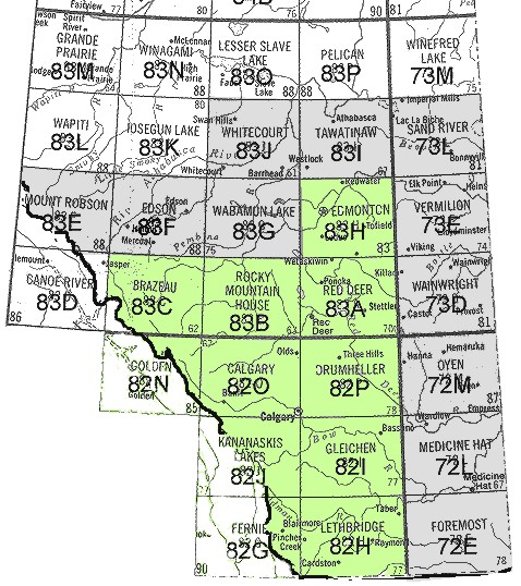
Alberta TERRAIN - 1:20 000 Digital Elevation Models
The GEODE archive includes Alberta Digital Elevation Models for the 11 NTS areas highlighted in green below on the map of Alberta. The digital files consist of three (3) dimensional digital elevation model (DEM) coordinate data, utilizing the National Topographic System (NTS) naming convention and dividing a 1:50 000 identifier into quadrants. DEM data is available in 100m regular grid. Each DEM file covers one (1) 1:20 000 map sheet area.A second set of DEM files, highlighted in grey below on the map, are available, but have not been processed as ArcInfo Grids. The files are in ascii DMDF format. Contact the MADGIC desk by email or phone at 220-8132 regarding access to these files.
Feature Classes:
Product Details: